Brevet-200km
Salisbury-Oakboro-Mt.Gilead-Brunsville-Locust-Mt.Pleasant-Salisbury-RUSA#697
Feb 07, 2009 Brevet 200k Salisbury, NC
Results
| Organizing Club | Bicycle For Life / 933057 |
|---|---|
| Region | NC: High Point |
| Date of Event | 2009/02/07 |
| Event Type | ACPB |
| Event Distance | 200 |
| Starters | 24 |
| Finishers | 24 |
| DNFs | 0 |
| RUSA # | Last Name | First Name | Time | From |
|---|---|---|---|---|
| 3560 | BLAINE | Ron | 08:51 | NC |
| 5335 | BURKHALTER | Jay | 11:02 | NC |
| 1609 | DAYTON | Michael J | 08:51 | NC |
| 3294 | DAYTON | Robert D | 13:23 | NC |
| 4070 | FURBISH | Dean | 11:02 | NC |
| 3928 | FAFROWICZ | JoAnn | 09:57 | NC |
| 3459 | FLORIAN | Mary J | 09:24 | NC |
| 3458 | FLORIAN | Thomas F | 09:24 | NC |
| 1526 | GOODNIGHT | Tony R | 08:27 | NC |
| 2618 | HOLLINGSWORTH | Joe Ray | 08:40 | NC |
| 3095 | JOHNSON | Wes | 08:40 | NC |
| 3099 | LATHE | Charles | 09:57 | NC |
| 692 | LAWRENCE | Joel | 08:51 | NC |
| 4649 | MORRIS | John | 09:24 | NC |
| 621 | MORTON | Byron E | 11:02 | NC |
| 825 | MULHEREN | Ed | 10:45 | NC |
| 3175 | OSBORNE | Lindley | 11:22 | NC |
| 3525 | PHELPS | Jerry | 09:57 | NC |
| 4866 | RICKS | Vance | 11:02 | NC |
| 3113 | SELLMER | Glenn | 11:02 | NC |
| 4296 | SHAFFER | Gary | 13:23 | NC |
| SHORE | Will | 08:40 | NC | |
| 1532 | STEWART | Jon David | 08:51 | NC |
| 1392 | WILLIAMS | James | 08:40 | NC |
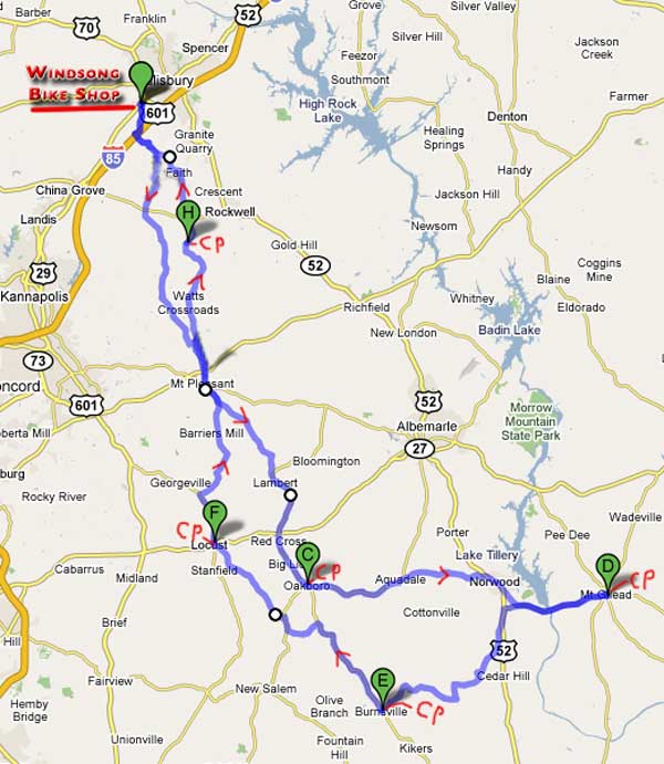
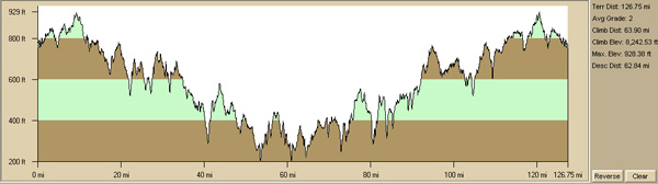
Distance was approximately 204 Kilometers (127 miles with about 8200 ft of total climbing), started at 7:30am from Windsong Bicycle Shop on Hwy 601 N - 2702 S. Main St. Salisbury, NC
Brevets are generally not races for which there is no prize money, so please be polite to all volunteers, fellow riders and convenience store attendants. Helping a fellow rider to finish is allowed and should make you feel better.
The spirit of randonneuring emphasizes self sufficiency. Personal sag vehicles are not allowed on the course and can only be used in certain situations defined in RUSA's Rules For Riders. You should also follow all local traffic laws, rules & regulations while participating in any brevet.
Please ensure that you dress appropriately for the weather conditions and have sufficient supplies and extra funds if needed for anything that may arise while en route on brevets!
This was an ACP-RUSA Brevet route number 697. The total time allowed from start to finish is 13.5 hours. The actual distance was approximately 204 Kilometers. Riders must follow and complete the approved route. This route goes through several small towns in central North Carolina traveling along mostly low traffic roads. There may be some sections where traffic is high, so please ride carefully and safely at all times. The intermediate controls are at the Oakboro, Mt Gilead, Burnsville, Locust, & intersection of Old Beatty Ford and Organ Church Rd where stores allow you to refuel with some basic supplies. There are also some other stores along the route where you may be able to stop and get limited nutritional supplies.
This map below is the basic route. Please note that all online images, que sheets and maps are for general reference. Offical routes will be provided at the event start for registered participants. Anoter map version is available by clicking on either map. There will also be a version on MapMyRide.
Approximate climbing is 8,200 feet using Topo Version 4
200k Que sheets
- may be available by request only
Brevet was held on Feb 7th, 2009