Brevet-200km RUSA credit only
Statesville, Lenoir, Adako, Jonas Ridge, Adako, Lenoir, Taylorsville, Statesville
Aug 1st, 2009 Brevet 200k Statesville, NC
Results
| Organizing Club | Bicycle For Life Club / 933057 |
|---|---|
| Region | NC: High Point |
| Date of Event | 2009/08/01 |
| Event Type | RUSAB |
| Event Distance | 205 |
| Starters | 2 |
| Finishers | 2 |
| DNFs | 0 |
| RUSA # | Last Name | First Name | State | Time |
|---|---|---|---|---|
| Wells | Douglas | NC | 10:42 | |
| Wells | Jonathan | NC | 10:42 |
Distance was approximately 205/224 Kilometers (128/140 miles with about 12,700 ft of total climbing)
The offical finish is in Hiddenite at 205 KM, so after you get your control card signed at the store in Hiddenite, you will need to ride from there to where you started, about an additional 12 miles.
Pre-Registration is strongly recommended for all events! If you do not pre-register your start may delayed or you may not be able to get credit for the brevet.
The route is a somewhat challenging route in places due to the terrain, but not such that most reasonably fit randonneurs would not be able to finish on time. Some of you may need a triple or low gear compact. You may need to watch your stop times and site seeing times, so consider planning to keep a steady effort on the easier sections. There are quite a few long down hills too.
Brevet started Aug 1, 2009 06:40 AM
Aug 1, 2009 • Sunrise 6:33 AM • Sunset 8:26 PM • 13h 53m 19s of daylight • EST
If you have not completed the brevet by Sunset you must have RUSA approved lights and reflective gear on and operational from Sunset to Sunrise or you will receive a DNF for the brevet.
Suggested donation is $15 per rider.
Brevets are generally not races and there is no prize money, so please be polite to all volunteers, fellow riders and convenience store attendants. Helping a fellow rider to finish is allowed and should make you feel better.
The spirit of randonneuring emphasizes self sufficiency. Personal sag vehicles are not allowed on the course and can only be used in certain situations defined in RUSA's Rules For Riders. You should also follow all local traffic laws, rules & regulations while participating in any brevet.
Please ensure that you dress appropriately for the weather conditions and have sufficient supplies and extra funds if needed for anything that may arise while en route on brevets!
Riders should pre-register online to allow them to start on time. You may also be able to register at the event prior to the start. It is strongly suggested that you pre-register. If you do not pre-register, your start may delayed or you may not be able to start with the other riders. Day of event registration may close at before the official event start time for Brevets.
This is an RUSA Brevet route number 783. The total time allowed from start to finish is 13.5 hours. The actual distance is approximately 206 Kilometers. Riders must follow and complete the approved route. This route goes through several small towns in central North Carolina traveling along mostly low traffic roads. There may be some sections where traffic is high, so please ride carefully and safely at all times. The intermediate controls are at the Charles, N. Wilkesboro & Charles where stores allow you to refuel with some basic supplies. There are also some other stores along the route where you may be able to stop and get limited nutritional supplies.
This is a basic route map. Please note that all online images, que sheets and maps are for general reference. Offical routes will be provided at the event start for registered participants. Anoter map version is available by clicking on either map.
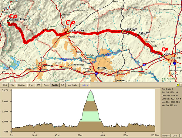
Approximate overall climbing is 12,700 feet using Topo Version 4
200k Que sheets
- may be available upon request only
Start location will be near I-40 exit 148 north off of US64/NC90 Statesville, NC
Shopping center across the street from the Economy Inn Statesville
View Larger Map