Brevet-600km
Statesville, nortwest SC, Western NC, Ashville, Rutherfordton, Statesville
Sept 5th, 2009 Brevet 600k Statesville, NC
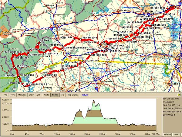
Distance is approximately 613 Kilometers (381 miles with about 41,600 ft of total climbing)
Pre-Registration is strongly recommended for all events! If you do not pre-register your start may delayed or you may not be able to get credit for the brevet.
The route has a very challenging middle section in places due to the terrain. Most of you will need a triple or low gear compact for some climbs. You will need to watch your stop times and site seeing times, so consider planning to keep a steady effort on the easier sections. There are many rolling sections and serval very long down hill sections too.
On Site Registration/inspection opens at Aug 1 2009 04:00am
Ecconmy Inn on Hwy US 64 / NC-90 near exit 148 I-40 Statesville, NC
Brevet starts at Sept 5th, 2009 05:00am
Sep 5, 2009 Sunrise-6:59AM Sunset-7:44PM Total time-12h 45m 09s
Sep 6, 2009 Sunrise-7:00AM Sunset-7:43PM Total time-12h 43m 01s
If you have not completed the brevet by Sunset you must have RUSA approved lights and reflective gear on and operational from Sunset to Sunrise or you will receive a DNF for the brevet.
Suggested donation is $45 per rider.
More INFO
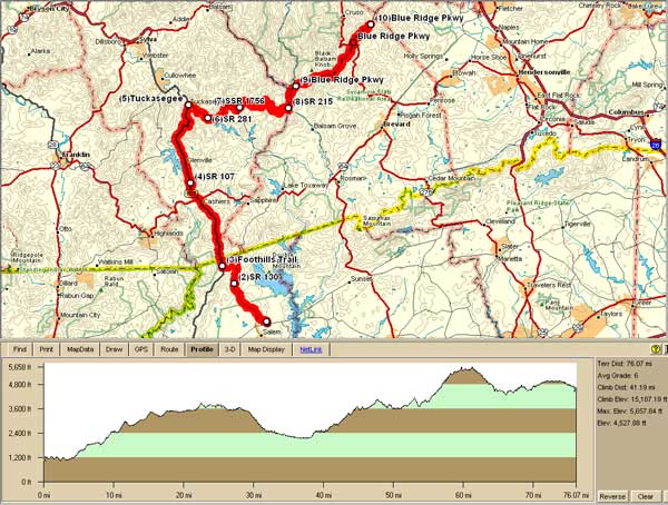
Start will be at 5am to help you maybe get to Cashiers (about mile 176) before the store at Hwy 64 & 107 close (supposed to be open until midnight). About mile 191 is Jimmy's Mini Market Store supposedly closes at 8:30pm in Tuckasegee at Hwy 107 & 281
As mentioned before there is a Secret control (mile 228) at the Pisgah Inn parking lot www.pisgahinn.com on the Blueridge Parkway. Phone (828) 235 8228 for reservations. Located south of Asheville, NC at Milepost 408.6, Pisgah Inn is the highest elevation lodging on the Blue Ridge Parkway at over 5,000 feet. The restaurant there quits seating people at 9pm.
One small brevet size drop bag will be allowed per rider for the control at the Pisgah Inn and be available in one of the rooms on the ground floor. Since checkin is not allowed until 3pm, we do not know which room it will be. Drop bags will be returned to the start at the end of the brevet time limit.
Please make sure your drop bag is well labeled and sealed properly to control what is inside it. No glass or delicate items in drop bags are allowed. Also no food or liquid containers, that may easily come open or spill during transport and handling, will be allowed.
We will not be responsible for any damaged, lost or misplaced items, but we will do the best we can to reasonably take care of your stuff in the drop bags.
Brevard has a Hampton Inn and a Holiday Inn Express close to the route. Hampton Inn had the best rates when I checked online especially through one of the discount sites. There are many hotels near Henderson also near the route.
Note: you may not receive assistance on the route by having someone/crew follow you on the route, but crew may meet you at any control and may use portions of the route to get to the controls since in some places there is only one good road traveling through that area. Please make sure that they will be very careful around or passing any bicyclists on the route or anytime.
Some limited support may be available, but please note that there is no guarantee that any support will be at any particular place or get to any place you may be, so please be prepared for whatever conditions/incidences may arise during the brevet. We will do what we can where we can if you do require minimal assistance along the route. Please make sure that you stay on route since you will be traveling in some very isolated areas as it is where there may not be any phone service or even people in the area.
Since we have been told, but cannot find any info online, there have been some bear warning, please make sure you are careful if you stop in the mountains, State or National Forest areas.
Brevets are generally not races and there is no prize money, so please be polite to all volunteers, fellow riders and convenience store attendants. Helping a fellow rider to finish is allowed and should make you feel better.
The spirit of randonneuring emphasizes self sufficiency. Personal sag vehicles are not allowed on the course and can only be used in certain situations defined in RUSA's Rules For Riders. You should also follow all local traffic laws, rules & regulations while participating in any brevet.
Please ensure that you dress appropriately for the weather conditions and have sufficient supplies and extra funds if needed for anything that may arise while en route on brevets!
Riders should pre-register online to allow them to start on time. You may also be able to register at the event prior to the start. It is strongly suggested that you pre-register. If you do not pre-register, your start may delayed or you may not be able to start with the other riders. Day of event registration may close at before the official event start time for Brevets.
This is an ACP-RUSA Brevet route number 796. The total time allowed from start to finish is 40 hours. The actual distance is approximately 600 Kilometers. Riders must follow and complete the approved route. This route goes through several small towns in North Carolina and South Carolina traveling along some low traffic roads. There may be some sections where traffic is high, so please ride carefully and safely at all times. Some intermediate controls are at stores to allow you to refuel with some basic supplies. There are also some other stores along the route where you may be able to stop and get limited nutritional supplies. There are long sections where there are no store, cell service or houses.
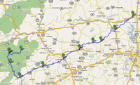
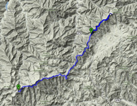
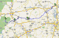
This is a basic route map. Please note that all online images, que sheets and maps are for general reference. Offical routes will be provided at the event start for registered participants. Anoter map version is available by clicking on either map.
This map shows the part of the climbing that will be the longest
|
Click on Below maps to see Google map details |
||
 |
 |
 |
| First 210 miles | Parkway 18 miles | Last 152 miles |
Approximate overall climbing is 41,600 feet using Topo Version 4
600k Que sheets
Start location will be near I-40 exit 148 north off of US64/NC90 Statesville, NC
-Economy Inn Statesville
View Larger Map